Mobile Imaging and Mapping Sets Sail
Mounting Trimble’s mobile mapping system on a boat solved the problem of scanning inaccessible infrastructure
Some areas of the massive Gemalink Port in southern Vietnam are inaccessible by land, making it difficult to capture the data needed to build a comprehensive digital twin of the facility. Using an innovative approach, Portcoast Consultant Corporation mounted a Trimble MX50 mobile mapping system on a boat to successfully scan the container terminal and nearby riverbank. The results were combined with terrestrial data to obtain a complete data set.
Gemalink Port serves global shipping needs
As one of only 19 major ports capable of receiving the world’s largest container ships, Gemalink Port on the Cai Mep-Thi Vai River in Vietnam is an important trans-shipment center for global trade. With its strategic location, it provides the country an economic boost while cutting costs and reducing the time it takes exports to reach the United States and Europe. Phase 1 of the facility began operations in January 2021, followed by Phase 2 in May 2021.
One year after opening the terminal, Portcoast Consultant Corporation, as a construction quality inspection consultant, conducted a full survey to update its as-built model. The digital twin serves many needs, from maintenance and BIM applications to verifying the length of the berths. Portcoast plans to conduct mapping updates every five years.
Collecting accurate point clouds in hard-to-reach places
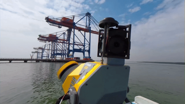
Trimble SX12 scanning total stations were used to collect data on land; however, a different approach was needed to capture the infrastructure facing the river. To solve the problem, a Trimble MX50 mobile mapping system was mounted on a wooden boat—40 feet in length, 10 feet wide, and 10 feet high—and slowly driven at an average speed of about 5 knots, maintaining a distance between boat and scanned objects of around 15 feet.
“We made sure the boat’s roof bars were strong enough to hold the roof rack (18 kg) and mapping sensor (23 kg),” said Dr. Hoang Hiep, vice general director at Portcoast. “And we adjusted the bracket position to orientate the roof rack horizontally as much as possible. That’s all there was to it.”
Driving or floating: same great results
The MX50 is typically mounted on a car or truck and driven at highway speeds to capture data for asset management, mapping, and road maintenance projects. Portcoast found that the operations on the boat delivered the same 360-degree color imagery and precise point cloud and met the desired accuracy of less than 1 to 2 cm. The small waves on the river had negligible effect on operations; in just 15 minutes the riverbank and river-facing infrastructure were scanned. Trimble Business Center and Applanix POSPac® Mobile Mapping Suite were used to process the MX50 data.

Portions of the container terminal inaccessible from land were mapped from the boat. Photo credit: Portcoast.

The Trimble MX50 mobile mapping system captured 360-degree color imagery and a high-density point cloud to be used as input for a digital twin.
Trimble Business Center is a field-to-finish survey software that helps surveyors deliver high-accuracy GNSS data, classify point clouds, clean up data, create CAD deliverables and leverage full data traceability throughout a project's lifecycle.
POSPac Mobile Mapping Suite is Applanix' next-generation, industry-leading software for direct georeferencing of mobile mapping sensors using GNSS and inertial technology. It is optimized for all environments (air, land, marine) and achieves both maximum accuracy and maximum efficiency.
“Mounted on a boat, the versatile MX50 mobile mapping system allows us to efficiently map hard-to-reach areas from the water, and on a vehicle we collect large areas such as industrial parks, express highways and cities.” - Dr. Hoang Hiep, Vice Director General, Portcoast
Terrestrial data for the container terminal was collected with the Trimble SX12 over a seven-day period with 60 scan stations. Targets on land helped register the MX50 scans and seamlessly merge both data sets.
“We used the same coordinate system to combine the riverbank data with land data,” said Hiep. “The result is used as the input for digital twin design and BIM-GIS.”
Complete digital picture improves operational efficiency
After scanning, the scan‐to‐BIM work was applied to create the BIM model of the complete container terminal, which was used as the input data for a simulation engine (i.e., Unity, Unreal Engine). The simulation program for the facility was created to replicate its operation in the virtual environment.
The digital model in the simulation program is linked to the physical model by mounting sensors on the physical infrastructure. The program enables users to observe in real‐time the port's operation and provide data such as working conditions, maintenance time, upgrade or replacement.
The Trimble MX50 and SX12 provided the complete 3D digital picture needed for the implementation of BIM processes to improve efficiency of operations and ongoing maintenance at the Gemalink Port.
“The excellent accuracy and reliability of Trimble’s survey equipment, along with competitive prices, are major selling points for Portcoast,” Hiep said.

The complete 3D digital model supports BIM processes to improve efficiency of operations and ongoing maintenance. Photo credit: Portcoast.
Solutions for this project included:
- Trimble® MX50 Mobile Mapping System
- Trimble SX12 Scanning Total Station
- Trimble Business Center Software
- Applanix POSPac Mobile Mapping Suite
Watch the solution in action here:
For more information on Trimble’s mobile mapping solutions, visit here.