What's New in Trimble Access 2021.10
Version 2021.10 of the Trimble® Access™ software was released on 7th June 2021.
The following is a summary of the main new features included in this release.
New Features
Layer Manager for managing linked files and feature layers
The new Layer manager feature enables you to easily control the files and data shown in the map. This means you can manage all files linked to the job and can make features visible and/or selectable in the map and in the Video screen.
You can access Layer manager from the map, the Job properties screen, or the Video screen.
Within Layer Manager, your files are grouped in separate tabs for faster viewing: Point files, Map files, Scans, and Inspections.
The Features tab can make features in the job visible and/or selectable from the map and in the Video screen by feature layer. The feature layers are defined in the Feature Library FXL file linked to the job. You can make features visible and/or selectable at the layer names level, or at the individual code level by expanding the layer names.
You can use the Filter tab to filter the job data shown in the map by measurement type or by creating a wildcard search, and enable Auto update to update the map as you make changes in the Layer manager.
New surface inspection methods
The Surface inspection Cogo function, introduced in Trimble Access version 2020.20, now includes some new methods:
- Scan to surface, where you can compare a scan to a surface.
Supported surface file types include TTM, DXF, and RXL, as well as whole objects or individual faces in an IFC model. - Scan to scan, where you can compare a scan or region against earlier scan data.
- Scan to vertical cylinder, where you can select three points to define the vertical cylinder you will use as the reference surface. (The existing Scan to cylinder method requires you to select two points that define the axis of the cylinder and then enter the radius of the cylinder).
All methods can be used with .rwcx scans created using a Trimble SX10 or SX12 scanning total station, or with regions created from .rwcx scans.
This example shows the overbreak/underbreak when comparing a scan to an IFC tunnel design.
There are also a number of other enhancements to Surface inspection, including viewing the inspection point cloud from the Video screen, using Store to save any inspection points selected in the map to the job and creating a surface inspection report from the Job/Export screen.
For more information, see the topic Surface inspection in the Trimble Access Help.
Create regions from scan point clouds
If you are working with .rwcx scans created using a Trimble SX10 or SX12 scanning total station, you can now create a region from selected scan points. A region contains scan points from one or more .rcwx scan point clouds, or from other regions. Creating a region provides a fast way to select only the scan points you are interested in and is especially useful when performing a surface inspection. To create a region, select the scan points to include on the map and then from the tap and hold menu, select Create region.
You can manage regions and scans, including renaming, deleting, and restoring deleted scans or regions, in the Scans tab of the Layer manager.
For more information, see the topic To manage scans in the Trimble Access Help.
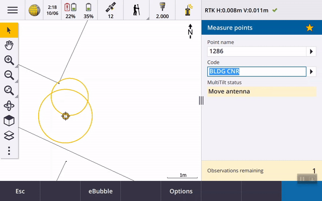
MultiTilt point measurement method for GNSS survey
When using a GNSS receiver with Tilt functions enabled in the survey style and a properly calibrated eBubble, you can use the new MultiTilt point measurement method to measure a point using three contributing tilted eBubble measurements in locations where you cannot level the pole.
This video will take you through MultiTilt point measurement in action:
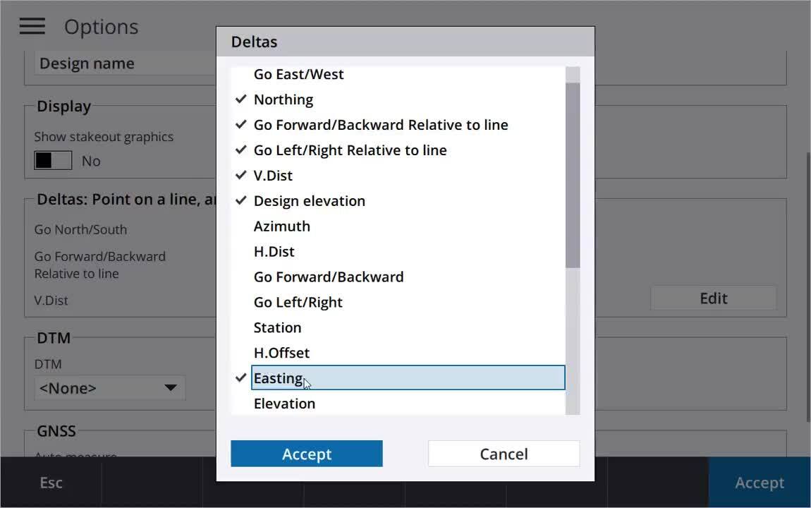
User configurable stakeout display
Trimble Access version 2021.10 features a customizable display when navigating during stakeout. You can choose whether to display stakeout navigation graphics. Hiding the graphics can be useful if you are using a controller with a smaller screen, or if you want to show a larger number of navigation deltas at a larger font.
This video shows some of the stakeout layout options on different controllers:
For more information please refer to the latest Release Notes.
Supported controllers
Windows 10 devices:
- Trimble TSC7 controller
- Trimble T7, T10 or T100 tablet
- Supported third-party Windows tablets
Android devices:
- Trimble TSC5 controller
- Trimble TDC600 handheld
- Trimble TCU5 controller
Upgrade notice
Cloud users must upgrade to Trimble Access 2021.10 by 31 August
Trimble Access 2021.10 includes important security updates for customers using subscriptions or who work with projects and jobs that reside in the cloud. To continue to sign in to Trimble Access with your Trimble Identity and be able to send data to and from Trimble Sync Manager or to use Trimble Access subscriptions, you must upgrade to Trimble Access version 2021.10 before August 31, 2021. (Cloud and subscription users still using version 2021.00 or earlier will not be able to sign in after August 31, 2021).
The latest Trimble Identity update provides multiple security and user experience features, including single sign-on. More information is available in this Support Bulletin.
For more information
For more information on specific topics you can also reference: